Lost in America

Sell everything and drop out for a year, cruising the western united states in an RV.

Friday, October 13, 2006

Big Tits!

Sorry guys, no naked pictures of Tracy, I'm refering to the Grand Tetons.

I'm at the library in Jackson (as in Jackson Hole for you ski buffs) right now. Jackson Hole refer's to the valley (or hole) first settled by a guy named Jackson. It is one great place. I thought I'd found "the place" until I checked out real estate prices. The Bay Area is actually cheap compared to Jackson Hole. It's one of those communities like Aspen where a few million is the minimum entry price.

For those who haven't been here (I remember Kalim got to go here for an all CAL during college) Jackson Hole is a big flat valley with the Grand Tetons jutting straight up on the side... very, very, steep, dramatic and beautiful. The town of Jackson has all you could want: theatre, movies, music, good hospital and library, lots of great restaurants, etc. and great hiking, biking, skiing, kayaking, rafting, fishing, and beautiful scenery surrounds you everywhere. Unfortunately others figured this out long ago and there is no such thing as a home under $1 million.

We went on two great hikes here.

The first was around Jenny lake, to the falls, then up to inspiration point for a view of the lake, valley and surrounding mountains, then up cascade canyon. As you can tell from the picture, it had snowed the day before. Grand Teton is right there, I mean right there as in goes straight up thousands of feet about a football field length from the trail. During the summer you probably get to see mountain climbers scaling the Tetons while you are on this hike. This has to be one of the most beautiful of all the hikes we have been on. A definate A+.


The second hike we made a loop around the north side of Two Oceans Lake up to another inspiration point (popular name around here) then around the southern end of Maggy Lake and back to the car at Two Oceans. 13+ miles and 800+ ft elevation gain total yesterday so today we decided to take a down day.

We are doing chores, including this blog, today and probably dinner and a movie tonight (the Friday night date night tradition is still going strong for us). Hope everyone is doing well. We haven't decided wether to head down the western side of the rockies and Utah next or the eastern side and Colorado or spend one more week north checking out Mount Rushmore, Crazy Horse, etc. I'm thinking of skipping Rushmore (it's notheast a couple hundred miles) and instead dropping down into Fort Collins, Colorado. Probably time to start heading south. Also I just got the message that Dave is getting married on the 22nd (lots of notice, Dave) so I'm going to try and get a flight out of Denver or Salt Lake or somewhere; hope to see some of you there.

Wednesday, October 11, 2006

Craters of the Moon

After Yellowstone we headed down to Idaho Falls to check it out. Nice town and your housing dollar goes a lot farther than a lot of other places we have been to. It's mostly a farming community but also has a fair amount of engineers due mostly to the Idaho nuclear research facility that is located here.

While there we spent a day on a side trip to the Craters of the Moon national monument. It's very aptly named as this is one weird, stark landscape created by unique volcanic action. It's not something I would make a special trip for but is worthwhile if your are in the area. Well I guess that means within 100 miles of the area since there's really no reason anyone would be much closer than that.


They are opening a Starbucks on this spot next year.


Tracy, what, where are you going? Don't leave me here!


These are called tree molds. They are left when lava surrounded a tree. The water in the tree cooled the lava enough to leave the imprint of the bark. The imprint, ridges and all are solid rock.

West Yellowstone

We spent one day in Southwest Yellowstone (Old Faithful area), one day in the Northwest (Mammoth Hot Springs area) and got rained out one day.

The old faithful area was all about geothermal features, especially geysers.
By making our first stop the visitors center and planning out our day we got to see lots of major geyser eruptions including: Lonestar, Old Faithful, Beehive (my favorite), Lion, Grand (Tracy’s favorite), Riverside and Grotto. We also got to see plenty of mud pots, fumaroles, pretty hot springs, etc. The trick is not to go to Old Faithful first but instead to just fit it and all the lesser features in around the other geysers. Old Faithful goes every 1.5 hours and isn’t the most impressive of the geysers, so don’t worry you won’t miss it. By the end of the day we were pretty geysered out.


Here’s a picture of a fox we got on the way back to the RV (we also saw lots of buffalo and elk) but by now they are so commonplace we don’t bother to stop.

The second day we were rained out and spent most of the day in West Yellowstone doing chores. Really cool thunder and lightning storm that night though.

The third day we decided to drive up to the Mammoth Hot Springs area. We walked all around the upper and lower boardwalks checking out the travertine terraces. The upper drive was closed due to road construction. This was cool because by hiking up there, getting in front of the road crew and doing it on foot, we got the whole area to ourselves.
The terraces are caused by minerals (most travertine) deposited by the water as it flows down the hill. The colors are caused by different types of bacteria that thrive in the hot water and high hydrogen sulphide content (it would be poison to us and the sulphuric acid produced by the bacteria is stronger than battery acid).

After the hike we went back to the car to have a late lunch and ended up watching elk for 3 hours. It is mating season here for the elk and there were three elk herds each with one 5 point plus male and their harem of 7-30 females per male; all within a football field of each other right down near where we parked. The males were strutting their stuff, bugeling at their females and each other (they steal each others females), rounding up their females if they start to wander off and generally being very aggressive. At one point we had one 50 feet to the right of the picnic table we were at and one 50 feet to the left both bugeling at each other. We thought they were going to attack each other meeting right about where we were so we quickly got out of the way.

There were two rangers whose whole job all day was to warn people away from the Elk. I was waiting to get one of those don’t let this happen to you pictures or maybe a short movie clip that would make the news. We did get to see one attack a truck that stuck around close for too long and there were a couple times when the rangers were busy elsewhere when some stupid tourists got very close to getting gored. Darn no luck though, all the tourists made it to safety (barely).

Tuesday, October 03, 2006

East Yellowstone

Since Yellowstone is so big we decided to camp in two different places. At first we would camp at Fishing Bridge in the east central part of Yellowstone (north end of Yellowstone Lake) then we would camp at Madison in the west central part of Yellowstone. This proved a good decision. Going from east central (Lake area) to the northeast (Tower area) is 45 minutes - hour drive in the funmobile depending on traffic; as is a trip down to the southeast (Lewis Lake) area.

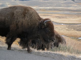
Oh by traffic I don’t mean Bay Area kind of traffic, I mean this kind of traffic:


Yep almost every time we end up waiting for Buffalo. It’s pretty amazing and kind of intimidating the first time but after you’ve been here a few days you get used to it and kind of wish they would get out of your way (though it’s still pretty cool). Sometimes there is a whole herd crossing the road. When this happens the adult males plant themselves in the middle of the road and wait for the females and especially the young to cross before moving on themselves. If it’s a big herd this can take awhile.

Sometimes they just decide it is their trail not these square shiny animals. Then they just walk right along it, frequently in the middle, and you just need to do your best to go around them. The monster (motorhome) fairs a little better though, they tend to go OK that square shiny animal is pretty big and get out of it’s way.


The first full day in Yellowstone we went down to Lewis lake (southeast). We kayaked across Lewis and up the river that connects it to the largest backcountry lake in the US (Shoshone Lake). It was a fairly long kayak (6 miles each way) but worth it. It was beautiful particularly the river that connects the two lakes:

The burnt trees you see are due to a fire that burnt over 30% of Yellowstone in 1988. For the most part they just let it burn (natural way of things) and it burned and burned all summer long. This was very controversial at the time as in the beginning they could have got it under control; however after a few weeks of letting it burn, there was nothing they could do anyway except pray for rain. They didn’t get any rain all summer and it wasn’t till the snows started in October that the fire finally went out.

There were also nice size trout all over in the river that connected Shoshone and Lewis. I could see schools of them as we paddled up. Periodically a fish would jump right near us as if to say, “Neener, neener, neener, you didn’t bring your pole, you dude!”

We also hit the West Thumb area of Yellowstone lake on our way back up from Lewis. This is a geothermal area. The one I liked the best is called fish pot hot spring. It’s a hot spring right on the edge of the lake (when the lake is high it’s actually in the lake). A few decades ago people would fish there, catch a fish then immediately swing their pole around and dunk the live fish in the hot spring to cook it. Unfortunately they don’t let you do that anymore. We also saw our first Elk and bison up close here.

Day two we biked up to a natural arch, hiked a 800 foot elevation gain to an overlook over Yellowstone Lake and then went and checked out another geothermal area called Mud Volcano and Dragon’s Breath. Most of the geothermal sites are right off the road so getting to them is no big deal.


Day three we woke up early and went out to the Hayden valley to see what animals we could see. We then did a bunch of hiking up, down and around the Grand Canyon of the Yellowstone (Uncle Tom’s stairs, Artists Point, Lower Yellowstone Falls, Lily Lake, etc.). Finally we hit another geothermal area nearby. The Yellowstone canyon is pretty cool, it’s a very deep and steep gash in the earth. The canyon walls are various shades of red, yellow, gray, etc. with the Yellowstone river run deep down in the bottom.


Day four we drove up to the tower area (northeast Yellowstone). We hiked up to the top of Mt. Washburn, elevation 10,243ft, unfortunately we didn’t get any good pictures as the view was spoiled by smoke from a wildfire in Montana. It was very windy and cold up there. The hike itself isn’t too bad, a gradual and constant gain of 1200 ft from the trailhead, but the lower oxygen at this altitude takes some getting used to. After Mt. Washburn we checked out tower falls and the rest of the area.

This woody is rock hard (petrified tree):

During the last four days we have seen various wildlife up close and personal including: bison (lots of bison), a bear and her cubs, Elk (including a 7 pointer), deer, a coyote, a fox and various birds.